| Name | Designation | Email & phone | Photo |
|---|---|---|---|
| Head of the Research Group | |||
| Dr. Sujit Kumar Mandal | Chief Scientist & HORG | E-mail : skm[dot]cimfr[at]gmail[dot]com, sujitkm[at]cimfr[dot]nic[dot]in Phone : 9431123474 (M) |
 |
| Section: 1 Mine Planning and Economics | |||
| Mr. Dilip Kumbhakar | Chief Scientist & HOS | E-mail : dilipcimfr[at]gmail[dot]com, dilip[at]cimfr[dot]nic[dot]in Phone : 9431729438 (M) |
 |
| Dr. Vineeth Balakrishnan Briefbiodata |
Sr. Scientist | E-mail : vineeth[at]cimfr[dot]nic[dot]in, discovervineeth[at]gmail[dot]com Phone : 8823068228 (M) |
 |
| Mr. Sandip Oraon | Sr. Technical Officer (2) | E-mail : sandiporaon[at]cimfr[dot]nic[dot]in, sandip_oraon[at]yahoo[dot]co[dot]in Phone : 0326-2296004/5, 4334 (Extn), 7250820979 (M) |
 |
| Mr. Guguloth Suresh Briefbiodata |
Technical Officer | E-mail : gsuresh[at]cimfr[dot]nic[dot]in, g[dot]sureshifs[at]gmail[dot]com Phone : 8099585820 (M) |
 |
| Mr. Anand Shyamji Sharma Briefbiodata |
Technical Officer | E-mail : anandsharma[at]cimfr[dot]nic[dot]in, sharmaanand5565[at]gmail[dot]com Phone : 9595009324, 9834803109 (M) |
 |
| Mrs. Prerna Jaiswal Briefbiodata |
Technical Assistant | E-mail : prerna[dot]sweetipie[at]gmail[dot]com Phone : 8789761615, 8540921749 (M) |
 |
| Section: 2 Mine Subsidence and Surveying | |||
| Dr. Amar Prakash Briefbiodata |
Sr. Principal Scientist & HOS | E-mail : amarprakash[at]cimfr[dot]nic[dot]in, amar_cmri[at]yahoo[dot]co[dot]in Phone : 9431315038 (M) |
 |
| Mr. Aniket Verma Briefbiodata |
Sr. Scientist | E-mail : aniketverma[at]cimfr[dot]nic[dot]in, aniket[dot]verma007[at]gmail[dot]com Phone : 8987452940 (M) |
 |
| Dr. Abhay Kumar Bharti Briefbiodata |
Scientist | E-mail : abhaybharti[at]cimfr[dot]nic[dot]in, abhay[dot]bharati1020[at]gmail[dot]com Phone : 8051056499 (M) |
 |
| Mr. Sanjivan Kumar Briefbiodata |
Technical Assistant | E-mail : sanjivan[at]cimfr[dot]nic[dot]in, sanjivansah[at]gmail[dot]com Phone : 7033265703 (M) |
 |
| Mr. Jagdeepa Oraon Briefbiodata |
Technical Assistant | E-mail : joraon[at]cimfr[dot]nic[dot]in, jaoraon123[at]gmail[dot]com Phone : 8271153136 (M) |
 |
| Mr. Simanta Sinha Briefbiodata |
Technician | E-mail : s[dot]sinhasurvey[at]gmail[dot]com Phone : 7001407505 (M) |
 |
| 13 Results |
| Sl. No. | A brief description of Facilities/ Equipment/Tools/software with photos |
|---|---|
| Major Facilities | |
| 1 |
Mine Planning Software Facility: Used for preparation of Mine Plans Minex, S urpac, Mineshed, Explo, Dymola, Vital
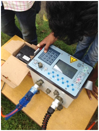
Trivector Analyzer: Instrument for different type of oil analysis
Oil Particle counter: The instrument particle counters are used for oil contamination analysis
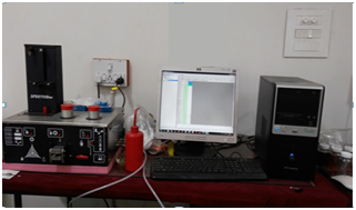
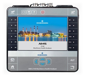
Machinery Health Analyzer: Instrument used for collection of vibration data on different machines
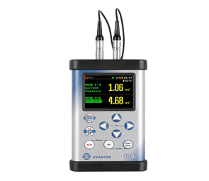
Vibration Meter: Six Channel Human Instrument used for collection of whole body vibration data on different motors, vehicles in various environment
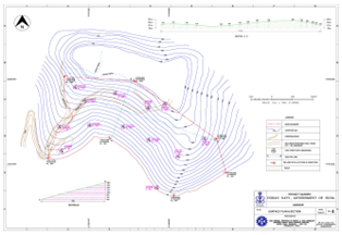
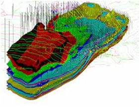
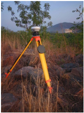
Topographical survey of large opencast mines and rugged terrain using Global Navigation Satellite System (GNSS).
Resistivity Imaging: for groundwater exploration, geological disturbances in natural and man-made underground workings, detection of sub-surface cavities, geological mappings, delineation of hard strata/weak zone etc.
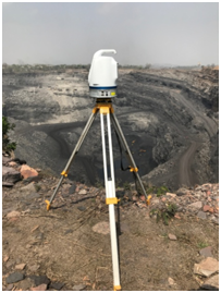
3D Laser Scanner for survey and volume calculation of excavated opencast mine, dump and stockpile using
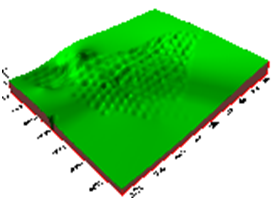
Prediction and control of subsidence movements under different geo-mining conditions using software tools, CivilCAD; LisCAD; Trimble Business Centre; ATLAScan; Prosys II |
| Sl.No. | Projects | Sponsor |
| 1 | Preparation of feasibility report for Drang (MohalBhatog) rock salt mine | Indian Salts Ltd. |
| 2 | Review of geological model and verify the annual production plan at Manoharpur and dip side of Manoarpur near Basundhara Area of MCL | Odisha Coal & Power Ltd. |
| 3 | Advice on vetting of Mining Plan of Taliha Graphite Deposit, Arunachal Pradesh | Stenos Cement Pvt. Ltd. |
| 4 | Advice on vetting of Mining Plan of Laa-Lamdak Area in Arunachal Pradesh | Skamord Mining Pvt Ltd. |
| 5 | Advice on vetting of Mining Plan of Bopi, Dodeserum and Tal Area in Arunachal Pradesh | Tasso Alloys Pvt. Ltd. |
| 6 | Data collection for preparation of mine closure plan of Khagra –Joydev coal mine of M/s DVC | Damodar Valley Corporation (DVC) |
| 7 | Design of safe excavation pattern and support and support system for proposed new railway tunnel between Ratanpur and Jamalpur stations | Eastern Railway |
| 8 | Monitoring of the excavation and support efficacy for the proposed new tunnel between Ratanpur and Jamalpur | Eastern Railway |
| 9 | Development of Microcontroller based fully automated coal transportation system | (CSIR-CIMFR) In-house |
| 10 | Development of continuous monitoring device to identify the rock fall in railway tunnel using Internet of Things (IoT) | (CSIR-CIMFR) In-house |
| 11 | Volumetric measurement of hired opencast of BCCL using 3D Terrestrial Laser Scanner | Bharat Coking Coal Ltd. |
| 12 | Advice for safe method of extraction of 5(S) Panel in 14 Seam with controlled effect on the floor of Magazine house at the surface at Bhelatand Colliery, Tata Steel. | TATA Steel |
| 13 | Volumetric measurement of opencast excavation of Khanak stone at Khanak using laser technology. | Haryana State Industrial & Infrastructural Development Corporation |
| 14 | Advice on subsidence prediction due to excavation at Longwall panels of seam-III & seam-I of Muraidih underground mine, Barora Area, BCCL. | Bharat Coking Coal Ltd. |
| 15 | Subsidence investigation over depillaring panels at Tata Steel Colliery of Jharia coalfield for safety of surface structure. | TATA Steel |
| 16 | Advice on subsidence prediction and management study pertaining to Jaganathpur-B coal block of Raniganj coalfield, West Bengal | Eastern Coalfields Ltd. |
| 17 | Scientific study to assess the efficiency of the support system during the working of the panel and thereafter continuously monitor the strata movement till the completion of extraction in the E3 panel underground mine of Pathakhera area, WCL | Western Coalfields Ltd. |
| 18 | Safety evaluation of different surface features and structures due to subsidence movements at Tata Steel collieries in Jharia coalfield | TATA Steel |
| 19 | Survey of surface topography as well as existing railway tunnel for laying the direction of proposed tunnel with respect to existing one at Jamalpur | Eastern Railways |
| 20 | Analysis of subsidence investigation over Longwall panel no. 2 at Adriyala Longwall project, SCCL | Singareni Collieries Company Ltd. (SCCL) |


To prepare techno-economically feasible mine plansfor optimum extraction of different mineral deposits; carry out investigations on subsidence prediction, monitoring and control measures and also to conduct surveying exercises using modern techniques and instruments.